
Rare cyclone heading to the Arabian Peninsula
A tropical cyclone that will bring strong winds and extreme rainfall is heading toward the Arabian Peninsula – it is likely to hit tonight and early Monday morning. It will be only the third to affect the region since reliable records began in 1979.
While it’s unlikely to affect the UAE, Cyclone Chapala will bring unprecedented wind and rain to the coastal parts of Oman and Yemen.
Yemen will be the most affected, but in our very-close neighbour Oman they expect more than eight times the annual rainfall when the cyclone is at its worst on early Monday morning.
A hailstorm has already hit the port city of Salalah, as seen in this video from around lunchtime today:
Families have been evacuated from a ‘high risk’ island off the southern coast of Oman and 23 schools in the Dhofar region have been turned into shelters that are currently housing over 4,000 evacuees.
Clare Nullis from the World Meteorological Organisation told Reuters: “The winds are a threat but we expect the biggest impact will be from the very, very, very serious rainfall.”
NASA has warned of the cyclone with its satellite imaging: the above image shows the extreme weather event over the Arabian Sea to the west of India at 1.10pm UAE time on Saturday October 30.
While travelling over the ocean the storm has intensified rapidly, with wind speeds accelerating from 105 to 250 kilometers per hour in a day, meaning it has just been upgraded to a ‘category 4’ cyclone.
The cyclone is likely to have been caused by the fact that this year’s temperatures are the warmest on record.
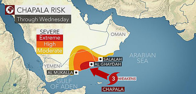 Accuweather shows how the cyclone is likely to hit.
Here’s what else Nasa had to say about its predicted progress: “Forecasts suggest Chapala will reach super cyclone category 5 status on October 31, but then weaken as it moves north and meets the extremely dry air of the Arabian Peninsula. It has the potential to make landfall in Yemen and Oman as a category 1 cyclone. But whether or not it sustains its winds, the storm should drop substantial rainfall over the parched region. Forecasters from the UK Met Office noted that the storm could produce up to 20 inches (500 millimeters) of rainfall in some places—four to five times the yearly average for the region. The storm is also having an impact on the busy shipping routes to the Indian Ocean through the Gulf of Aden.”
We’ll keep you updated if the cyclone’s path changes, meaning it will hit the UAE, but in the meantime we hope our neighbours over in Oman and Yemen stay safe.
#TropicalStorm #Ashobaa churns off the coast of #Oman. Stay safe down there. #YearInSpace pic.twitter.com/7047MGIymT
— Scott Kelly (@StationCDRKelly) October 31, 2015